City Cast Portland logo
Advertisement image

What’s the Deal With Portland’s Go-Slow Signs?

Posted on November 14, 2022   |   Updated on September 30, 2025

Rachel Monahan

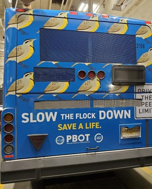
The city is offering yard signs and running billboards trying to get drivers to go slow. (Courtesy PBOT)

The city is offering yard signs and running billboards trying to get drivers to go slow. (Courtesy PBOT)

“Slow the Flock Down” read signs all across town.

That’s an official warning from the Portland Bureau of Transportation, which is hoping to reduce traffic fatalities. The city is also “redesigning streets, lowering speed limits, expanding its speed safety camera program, and educating drivers,” says Hannah Schafer, who’s now interim director of communications for PBOT.

I asked Schafer about the notable signs.
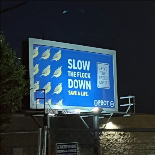
Portland has put a bird on their effort to slow cars down. (Courtesy PBOT)

Portland has put a bird on their effort to slow cars down. (Courtesy PBOT)

What made the city think these are the signs that could get people to slow down? 
“1) Its catchy, tongue-in-cheek style is an attention grabber, 2) It has a very clear and focused message, and 3) [The Seattle Department of Transportation, which brought Portland the idea] had tested the message and found that it resonated with a wide range of participants, but particularly younger men. [And according to federal data from 2020,] 16- to 29-year-old males had the highest traffic fatality rate of any demographic group.”

Is there any evidence that the signs are working? 
“It’s really hard to draw a direct correlation between a traffic PSA and how it impacts people’s travel behavior. We have seen a high level of interest and appreciation for this campaign and that tells us it is resonating with Portlanders. This is just one piece of the larger education and engineering work PBOT is doing.”

Why should people slow (the flock) down in Portland? 
“At the end of the day, it comes down to basic physics. By slowing down you are reducing the risk of hurting yourself and others on the road. Nationally, according to the U.S. Department of Transportation’s Fatality Analysis Reporting System, speeding is involved in about 30% of all traffic deaths. In Portland, it’s closer to 50%.” 
Share article

Hey Portland

Stay connected to City Cast Portland and get ready to join the local conversation.

Can't subscribe? Turn off your ad blocker and try again.

Portland, Explained

See All
Portland, ExplainedAugust 27

How Well Do You Know Our Local Mascots?

Portland Fire, the city’s WNBA team, revealed their new mascot this week after much fanfare.

Pink dragon in a Fire jersey.
Portland, ExplainedMarch 10

The Portland Area’s Local Income Taxes, Explained

Here’s a reminder on all our local taxes due today: The Portland Arts Tax, Metro Supportive Housing Services, and Multnomah County Presch...

Cropped shot of Asian woman sitting at dining table, handling personal finance with laptop.
Portland, ExplainedFebruary 4

How Weird Is Portland's Warm Sunny Weather?

The dry, warm winter continues. Outdoor guide and lifelong Oregonian Norther Emily talked to City Cast Portland podcast host Claudia Meza...

daffodils, Portland, Oregon
Portland, ExplainedDecember 17, 2025

Portland's Water Comes From a Rain Forest

Clean and plentiful tap water is one of those creature comforts we usually never think about. But where does Portland’s water come from?...

a reservoir amid scenic forest and mountains in background
Portland, ExplainedDecember 16, 2025

Oregon Hunger, Explained

This fall, during the government shutdown, the Trump administration took the unprecedented step of temporarily cutting off federal food b...

vast container of green apples being bagged up
Portland, ExplainedDecember 9, 2025

Portland's Atmospheric River May Cause Flooding

Portland is getting a ton of rain right now. We’re in the midst of a weather phenomenon called an atmospheric river.

clouds over the Willamette River, Portland, Oregon, with highway traffic on right
Portland, ExplainedDecember 3, 2025

When Will the Snow Start on Mt. Hood?

Ski resorts like Timberline and Mt. Hood Meadows have yet to announce their opening days, so snowboarders and skiers are eyeing the forec...

snowy slope and a blue sky with mountain ranges in the background. Mt Hood, Oregon
Portland, ExplainedDecember 2, 2025

Why the Portland Airport Is Called PDX

Even an alien invader might notice that Portland regularly favors the nickname PDX — our airport abbreviation. That’s clear enough. But w...

Natural light shines on the unique print of the PDX portland airport carpet. Shadows from the support beams are present.

The latest in Portland

Neighborhood GuidesSeptember 27

Your Guide to Kerns

When members of the Holy Trinity Greek Orthodox Cathedral moved into the large church at the corner of Northeast Glisan Street and 32nd A...

A street view from the corner of Northeast Glisan Street and Northeast 28th Avenue of the Apambichao Building, a cream and white colored Victorian apartment building that sits above Pambiche, a Cuban restaurant painted a deep blue.
Food & DrinkSeptember 27

Take a Tour of Franz Bakery in Portland

There are some things you knead to dough (sorry, seasonal allergies are the worst) about Franz Bakery, a fifth-generation, family-owned b...

Loaves of Franz bread tumble off of a conveyor belt at Franz Bakery in Portland, Oregon.
The Weekly Wander by City Cast PortlandSeptember 20

Side Quest: Go Big or Gourd Home

It’s almost pumpkin patch season on Sauvie Island, that time of year when caravans arrive in search of colorful squash to carve, and appl...

A pile of orange and green pumpkins at the entrance to The Pumpkin Patch on Sauvie Island. In the background, there’s a large red barn and farm store.
The Weekly Wander by City Cast PortlandSeptember 20

Your Guide to Sauvie Island

Located about 10 miles northwest of downtown Portland, Sauvie Island is a slice of nature that draws city folks year-round.

A flock of geese descends toward the Multnomah Channel and Sauvie Island. Kayakers can be seen on the water and in the background, the Wapato Bridge rises above a floating home community.
The Weekly Wander by City Cast PortlandSeptember 13

Side Quest: Charting History’s Course

While most of the Overlook neighborhood sits above the bluffs, the industrial area of Swan Island down below does actually fall within it...

An aerial photo from 1935 shows the Swan Island airstrip, built on a peninsula that juts out into Portland’s Willamette River.
The Weekly Wander by City Cast PortlandSeptember 13

Your Guide to Overlook

Beyond the views, the North Portland neighborhood has plenty of perks: access to the MAX Yellow Line, cocktail lounges, and residents who...

Branches with green leaves frame a view of Portland’s Fremont Bridge with skyscrapers behind it.
The Weekly Wander by City Cast PortlandSeptember 6

Side Quest: Pre-Game Routine

We don’t want to throw you off your game, but we do have some fun suggestions to spice up your traditions on the way to the Rose Quarter...

Banners and window art on the Moda Center show Portland Trail Blazers figures and history. In front of the arena, a person rides a bike by a sign that spells out Rip City.
The Weekly Wander by City Cast PortlandSeptember 6

Your Guide to the Lloyd District

For 66 years, the Lloyd Center was a place where Portlanders made memories, went shopping and ice skating, and even put in the miles mall...

An aerial shot shows the roof and twin glass spires of the Oregon Convention Center, with high-rise office buildings of the Lloyd District in the background.